Sea level rise is expected to impact the lower Columbia River and estuary in a number of ways. Because of the extensive loss of tidal wetlands that has already occurred over the last century due to other, more direct human activity, one of the biggest habitat threats that sea level rise presents is the loss of additional tidal wetland areas as a result of increased tidal inundation. These wetlands provide critical habitat for numerous species, including critically endangered and threatened juvenile salmonid species.
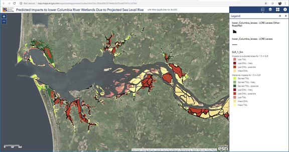
The Estuary Partnership recently completed a baseline assessment of potential impacts to lower Columbia River tidal wetlands and created on an online interactive map to illustrate the results.
-
How Can Sea Level Rise Impact Wetlands?
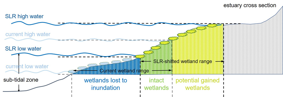
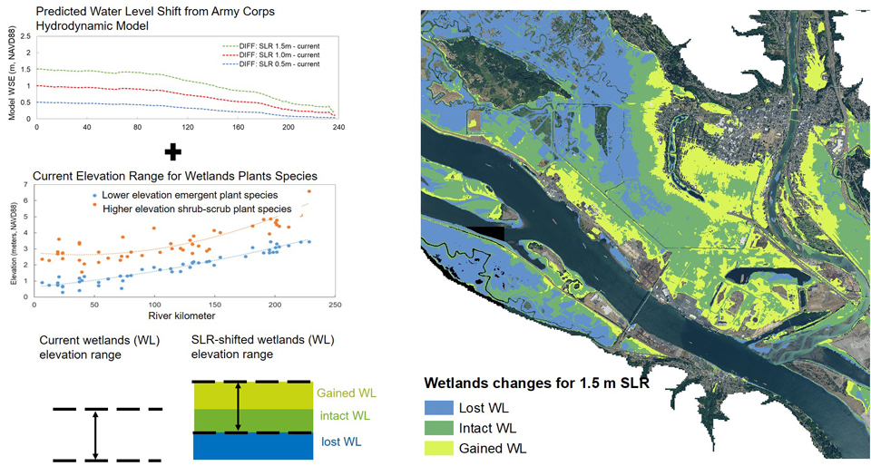
In the lower Columbia River and estuary, tidal wetlands exist where the influences of ocean tide and upstream river flow result in periodic inundation by water. The simple graphic below illustrates what can happen to wetlands under a sea level rise scenario. As sea level rises, the tidal range shifts higher in elevation accordingly. This can result in loss of lower lying wetland areas that become permanently inundated; possible creation of wetlands in higher elevation, newly inundated areas; and wetlands at mid elevations that remain intact.
-
How Much Will Sea Level Rise?
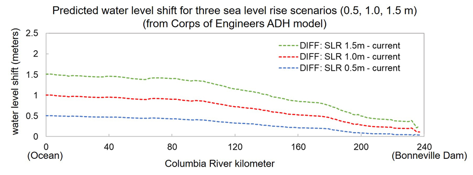
 Sea level rise is a complicated process, and the amount of rise that any given coastal area will see is dependent on many different factors. In 2018, the Washington Coastal Hazards Resiliency Network (WCHRN) published projected sea level rise estimates for the state of Washington, which includes the Columbia River. According to the report, sea level at the mouth of the Columbia River is likely to rise by as much as 2.0 feet (0.6 m) by 2100 and 3.7 feet (1.1 m) by 2150.
How will sea level rise that occurs at the mouth of the Columbia River affect water levels throughout the lower Columbia River? Although the tides affect the river all the way up to Bonneville Dam at river mile 145, the tidal influence decreases steadily with distance upriver. Therefore, the largest changes will be seen in the estuary, with less and less change proceeding upriver. This effect can be seen in the graphic below, which shows results from a U.S. Army Corps of Engineers modeling study that looked at how water levels in the river are expected to change when sea level at the mouth is increased by 0.5, 1.0 and 1.5 meters. These levels of increase are consistent with what has been published by the WCHRN. As can be seen in the graphic, when these increases are applied at the river mouth (river kilometer 0, or the Ocean), the resulting water level increase, or shift, gets smaller and smaller with distance upstream, all the way up to the Bonneville Dam at river kilometer 240.
-
How Are We Assessing Sea Level Rise Impacts to lower Columbia Wetlands?
Our analysis is based on the assumption that the relationship between the current elevation range of wetlands plant species and the current inundation range due to combined tidal and fluvial hydrodynamic forces will remain constant in the future. Given this assumption, we use GIS software to shift the current plant species elevation range (obtained from several years of data collected through our Ecosystem Monitoring Program) by the amount of expected water level shift (obtained from the Corps of Engineers hydrodynamic model results), to obtain a 'future' wetlands elevation range for each of the three sea level rise scenarios that we analyzed (0.5, 1.0, and 1.5 meters). The 'current' and expected 'future' wetlands elevation ranges can then be overlaid in GIS to map areas of 'lost', 'intact' and 'gained' wetlands that are predicted for each future sea level rise scenario. The process is summarized in the following graphic:
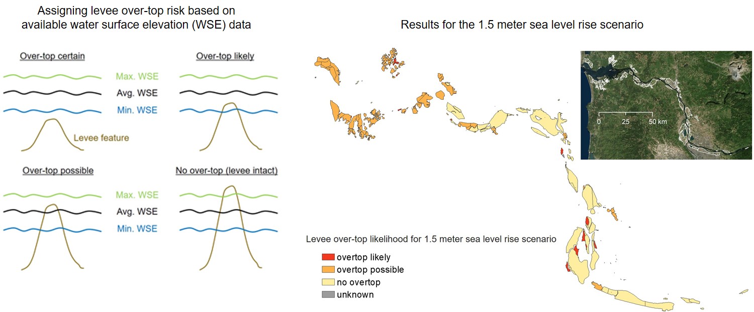
Because of the extensive levee system of the lower Columbia, which currently isolates the river from it's floodplain in many areas, a second step of analysis is needed to assess how each sea level rise scenario may impact these areas. For example, areas behind higher levees that are not predicted to over-top are less likely to be impacted, whereas areas behind lower levees that might significantly over-top could show promise of wetlands gain (or additional loss, depending on their respective elevations). Using the levee elevation data and water surface predictions that we had available, we used GIS to assess the risk of over-topping for all existing diked areas in the system, and included those results in our final analysis. Because our information was limited, we consider this a coarse assessment only and assign a range of certainty to our results, ranging from what we think is the most 'likely' outcome to what we consider a 'possible' outcome, based on what the levee analysis is showing:
-
What Is Our Analysis Telling Us?
Our analysis of the potential impact on lower Columbia River wetlands due to sea level rise has revealed a number of interesting things, and also highlighted the need for more detailed study.
Habitat Loss:
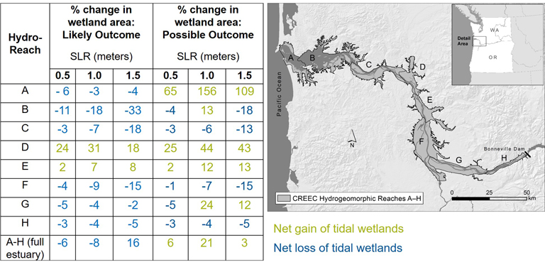
Even under the most dire sea level rise scenario that we modeled, which has a low probability of occurring within the next 80 years, overall loss of wetland habitat may not be as great as we expected our model to show. The figure below shows predicted changes in overall wetland area relative to the current extent, within different management reaches (hydro-reaches) of the lower river (and overall) for each sea level rise scenario. Under the worst-case rise of 1.5 meters, overall wetland area for the most likely outcome is predicted to decrease by 16%, and less than that (6% and 8% respectively) for the 0.5 and 1.0 meter scenarios. Under a 'Possible' outcome, where levee over-topping occurs and allows for wetland formation, actual increases in overall wetland area could even occur (+6%, +21%, +3% respectively for the 0.5, 1.0 and 1.5 meter rise scenarios).
Despite the relatively small worst-case wetlands losses predicted by the model, when considering the extensive loss of tidal wetland habitat that already has occurred over the last century, any amount of loss is of significant concern. Habitat restoration may be able to offset some of the losses that are expected to occur. Targeted restoration actions in areas where levees are susceptible to over-topping, and where significant habitat gains could potentially occur is one strategy we are looking at.
Risk to Infrastructure
While not a direct objective of this study, our model provides baseline information about where levees, and thus infrastructure behind them that they protect, are most vulnerable to sea level rise. This is potentially useful information to communities, municipalities, stakeholders and other management entities in the region that will need to make planning decisions around the future onset of sea level rise.
-
Where Can I See the Results?
Results of the analysis can be viewed in an interactive map application by clicking the icon below. The map shows predicted changes to tidal wetland areas which are not currently isolated by levees, and also the vulnerability to levees and diked floodplain areas, based on the limited analysis that we were able to perform.
A 2-page summary report of the analysis is also available.