About this location
- NOAA Chart
-
US5OR14M
-
Water trailColumbia River
- River Mile
-
98
- Restrooms
-
Yes
- Parking Type
-
Day - Site parking is available 100 yards away along Hwy 30.
- Parking Fee
-
None
- Tidal influence
-
Moderate
-
Launch TypeRamp
- Launch Fees
-
$2
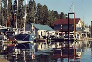
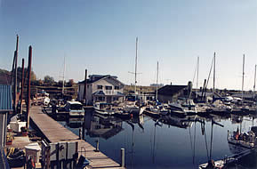
The facility is a well lighted, secure marina located midpoint on the Multnomah Channel at river mile 14 (land mile 16 on Hwy 30). The marina includes a fuel dock dispensing gas, diesel, and propane, a small convenience store, restrooms included with showers, washers and dryers for tenants and for the public.
'Rocky Point Landing,' as this locality was known in the 1870's, was the eastern terminus of a road that meandered through the hills between Hillsboro and Sauvie Island. A ferry made regular trips between Sauvie Island and Rocky Point Landing. At that time, Rocky Point Landing consisted of a store, a post office, a school and a sawmill. This settlement disappeared in the early 1900's. In the late 1920's a rock quarry was developed by Porter-Yett Co. The Porter-Yett Co. quarried nearly all the rock for the St. Johns Bridge construction site from the Rocky Point Landing quarry.
Site owner
Rocky Pointe Marina
Address
23586 NW St. Helens Highway
Portland, OR 97231
United States