The Estuary Partnership had a busy year! Here are a handful of highlights from 2017:
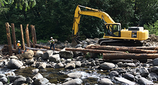
Completed construction of two habitat restoration sites: In partnership with the US Forest Service, we restored a section of Hamilton Creek in Skamania County by adding 200 pieces of large wood to the creek to add habitat complexity, and revegetating the area with 9,000 conifers and willows. The East Fork Lewis River also got a rehab for salmon and steelhead, with an Estuary Partnership-led project that excavated a side channel to reconnect it to the East Fork Lewis mainstem. The project also added 200 pieces of large wood, removed invasive plants and, over the next few years, will replant 12 acres with 24,000 native plants. This project is in partnership with Clark County, and is just upstream from our 2015 La Center Floodplain Wetlands Restoration Project, where our plantings are already pushing 12 feet high and forming a closed forested canopy.
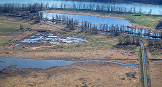
Completed 60% design for Steigerwald: Our Steigerwald Floodplain Restoration Project will reconnect 960 acres of floodplain to the Columbia River and reduce flood risks to the Port of Camas-Washougal and nearby property owners. In May, Governor Inslee toured the project – he noted that with its student education component and its habitat restoration work, the project is good for both juvenile humans and juvenile salmon. We completed the 60% design plans, and construction is scheduled to begin in 2019. In the first weeks of 2018, the Washington legislature provided $4.6 million in funding from the Washington State Department of Ecology’s Floodplains by Design Program for key project elements.
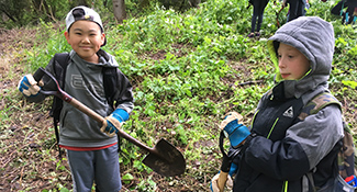
Expanded work with Clackamas County students: Thanks to a grant from Clackamas County Water Environment Services, we worked with Clackamas County students to provide them with watershed health education. Our educators worked with 9 classes from 3 schools in 2017, with another 14 classes from 5 schools scheduled for class visits and field trips during the remainder of the 2017-18 school year.
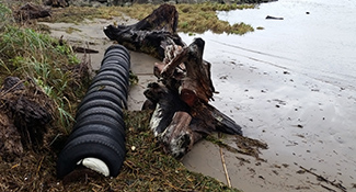
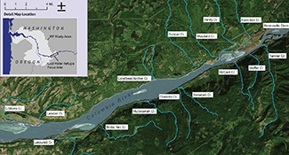
Expanded marine debris tracking: In 2016, we launched the first large-scale effort to track marine debris along the lower Columbia River. In September, we surveyed nearly 200 miles of Washington and Oregon shoreline in the 37 river miles between Cathlamet and Kalama. We mapped 107 instances of medium-sized debris like old tires, Styrofoam, barrels, and small abandoned boats. This builds on our initial survey in fall 2016 between Kalama and Portland, which catalogued 162 debris locations. In 2018, we will also conduct a small island shoreline survey of plastic microdebris. These efforts will help us secure funding and focus our efforts on areas that most need clean up. View the map to see where we’ve found debris. If you find any, please enter it into our database through our Submittal Form.
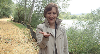
Congressional Estuary Caucus formed: Representatives Suzanne Bonamici (D-OR), Rick Larsen (D- WA), Bill Posey (R-FL), and Frank LoBiondo (R-NJ) founded and co-chair the new Congressional Estuary Caucus. The bipartisan caucus unites lawmakers to keep our nation’s estuaries strong and to protect our local economies and critical ecosystems. We are thrilled that one of our own representatives was among the founding members of the caucus. Estuary Partnership Executive Director Debrah Marriott was invited to address the caucus at its first work session in March. Representative Bonamici (left, at a visit to our Batwater Station restoration site) has been a staunch supporter of the lower Columbia River and estuary her entire political career. To date, a total of 36 representatives from around the U.S. have joined the caucus.
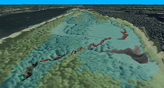
Developed and refined scientific tools: We expanded our hydraulic modeling to 3-dimensions, allowing us to better predict how physical factors like temperature vary throughout the water and aiding our ongoing research on cold water refuges (see below). We also worked on a Habitat Performance Index to evaluate habitat conditions, helping us determine how a restoration project is reaching its intended goals. Projects can take decades to recover to a mature ecological state, making it challenging to assess how they are progressing. The Index incorporates factors like landscape, water quality, and presence of prey to discern where the site is on a trajectory of recovery. All of our tools and research is shared freely with other groups and individuals.
Tested models to boost cold water areas along the mainstem: The Estuary Partnership is testing new techniques to enhance cold water refuges in the lower Columbia River, to help migrating salmon on the mainstem during predicted warmer summers. If we do not adapt our habitat restoration techniques to account for such changes as warmer temperatures, the long-term outlook for salmon in the lower river is bleak. Using 3D models, we are assessing how physical structures of varying size and orientation placed at tributary confluences can form protected pockets of cold water big enough for salmon to find them during migration.
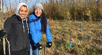
Hosted stewardship projects with students and/or volunteers at 14 sites, planting more than 6,000 trees.
In Washington: Salmon Creek, Vancouver Lake, La Center Bottoms, Steigerwald Lake National Wildlife Refuge, Burnt Bridge Creek, and Whipple Creek.
In Oregon: Sandy River Delta, Oxbow Regional Park, Scappoose Bay, Coffenbury Lake, Horsetail Creek, Ross Island, Meldrum Bar Park, and Clatskanie Elementary School grounds.