Reach: 7
Distance: 7 miles from John Day River to West Mooring Basin
Chart: NOAA Chart 18521, Columbia River, Pacific Ocean to Harrington Point
Skill level: Intermediate
Paddling along Astoria’s waterfront, we get two simultaneous greetings. One is from the new face of Astoria and the other from a longtime resident.
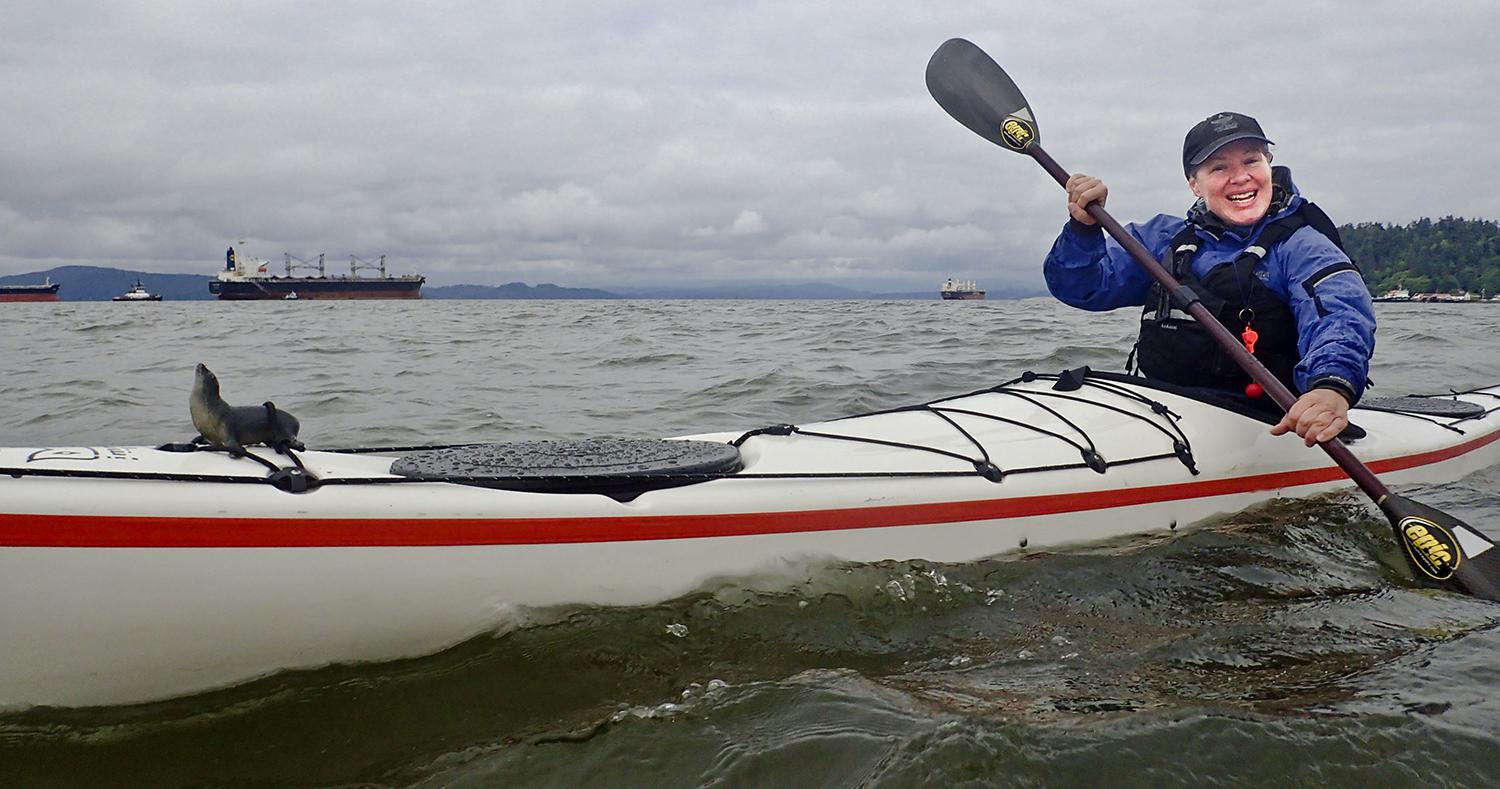
The first is from a woman in a modern condo built atop an old cannery pier. She comes out onto her porch to say hi. Her sparkling new condo would fit in just fine in San Francisco’s Embarcadero or Baltimore’s Inner Harbor. The second greeting—a less welcoming deep baritone—is from her downstairs neighbors. They’re some of the Astoria’s longtime, blue-collar fishermen: a quartet of sea lion bulls lounging amidst the pilings. They bellow loudly when we enter their territory. Welcome to the changing face of Astoria, as seen from the wide, wild Columbia River.
The day’s plan is to paddle around Tongue Point and along the waterfront to give us the whole spectrum of Astoria by kayak. We’ll start in the near-pristine and protected waters of Cathlamet Bay east of Tongue Point. Rounding Tongue Point on the ebb, we will investigate the tide rips that often form where the outbound current wraps around the jutting peninsula. We’ll eat lunch at the East Mooring Basin, the usual takeout, to extend our paddle under the giant span of the Lewis & Clark Bridge, to a second car at the West Mooring Basin. Launching at the start of the morning’s ebb current, we should get a free ride most of the way—unless a strong west wind came up.
From the start, we realize that we’re out of tune with a major aspect of life in Astoria: sport fishing. Today is the last day before restrictions on fall Chinook tighten, so both the West Mooring Basin and the John Day River are packed with boat trailers. After some hunting we find a spot, dodge the slippery baitfish on the boat ramp, and launch into the John Day River, a small tributary of Cathlamet Bay.
Cathlamet Bay is a wide, shallow, marshy bay of islands that change form as the tide changes. With the exception of the Mott Basin marina, it’s undeveloped, and Lois and Mott islands form the western boundary of the Lewis and Clark Wildlife Refuge. Terns and gulls wheel about as we poke along grassy islands. Then we cross to Tongue Point.
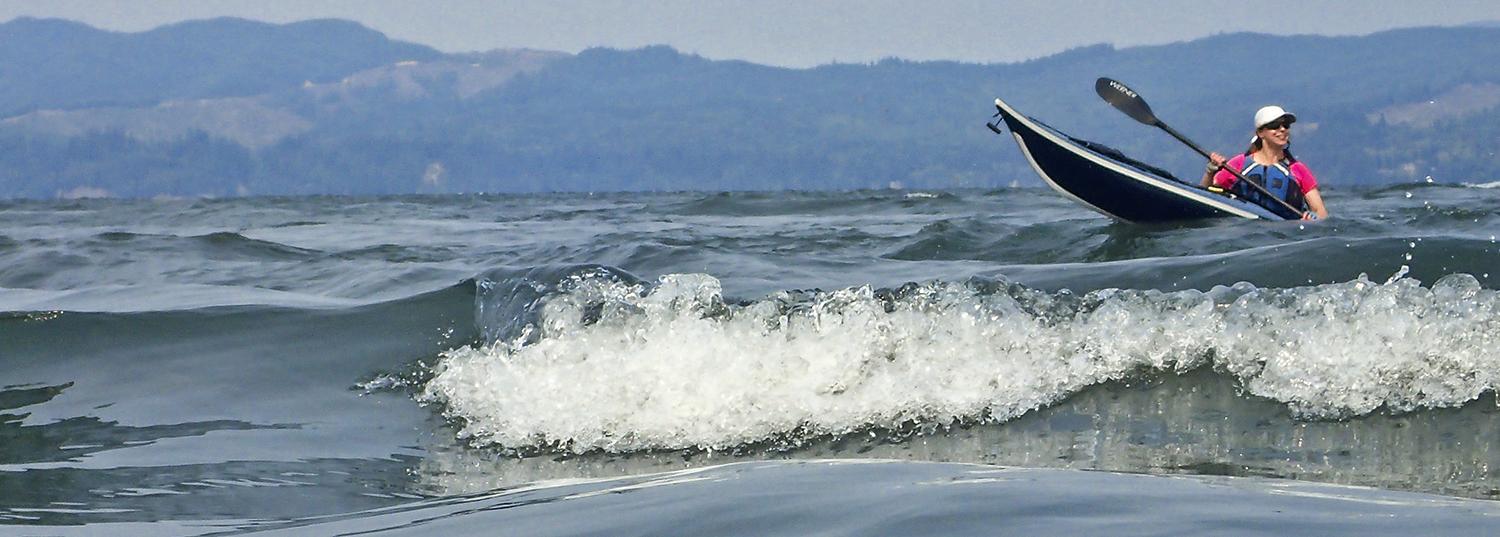
An aptly named peninsula, Tongue Point juts into the Columbia. It also magnifies current. By design, we arrive near max ebb current to see if a play spot develops. We stop in the slow-water eddies behind a navigation light and the point itself. The current flowing over the shallows forms a series of glassy waves, and Karen and I spend some time surfing them upriver. A tanker, a barge, and a big fishing boat are heading seaward, and their wakes magnify the waves into good surfing form.
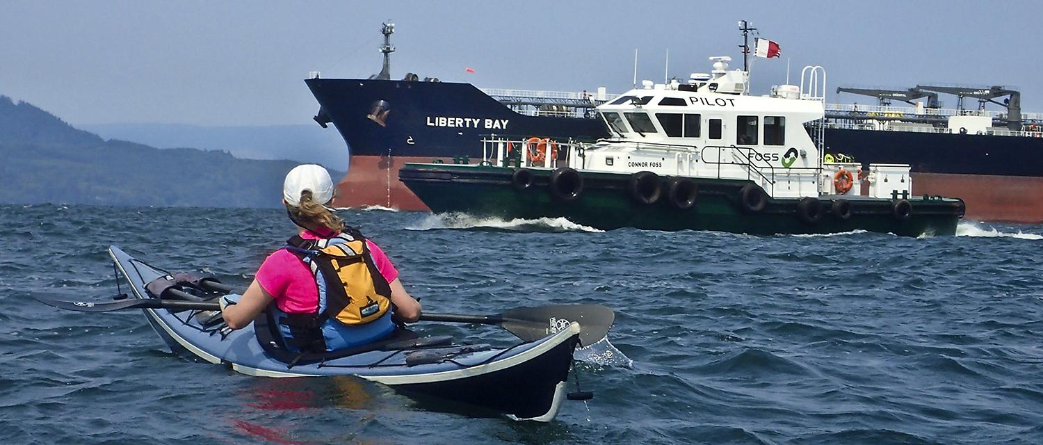
When we round Tongue Point, the first visible sign of Astoria is five behemoth tankers and container ships anchored west of the point, with the graceful curve of the Astoria Bridge in the background. We thread our way between two container ships: the Spring Warbler, which is about as unlike a delicate songbird as I can imagine, and the more aptly named Bulk Titan. Then we set a course for the East Mooring Basin. There we encounter two other Astoria hallmarks.
The first is the rising west wind, about as reliable as the occurrence of afternoon. Since we timed our paddle to ride the westbound current, the wind-against-tide scenario creates chop and whitecaps, but the ebb still zips us along.
When we duck into the East Mooring Basin for a lunch break, we’re greeted by the second icon: sea lions. They’ve taken over the East Mooring Basin dock much like at San Francisco’s Pier 39—except there are more of them, and it’s easier to park. Various attempts to move them along have been tried, including beach balls, noise, and fiberglass orca whales. None have worked. The dock has one of the world’s most hilariously obvious signs: “Caution: Sea Lions on Dock.” You can’t even see the dock, and the sea lions clamber over each other to reach the water. Between the sea lions and the crowded boat ramp on a popular fishing day, we paddle past, giving the barking pinnipeds a wide berth, and take out at the public dock next to the Astoria Maritime Museum for lunch.
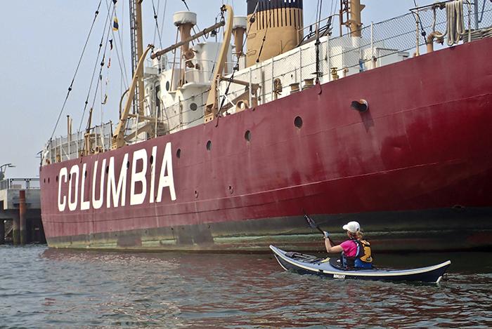
From the Maritime Museum, we get a good view of Astoria. The Columbia lightship is docked here. It used to sit out at sea for weeks on end in the years before permanent navigation lights, acting as a floating lighthouse five miles out to sea past the mouth of the Columbia. Now’s it’s part of the museum. Behind us, another ship has also found a new use. The Bowpicker is a fishing boat converted into a food cart serving fish and chips. It usually sports an hour-long line, and has become a town attraction.
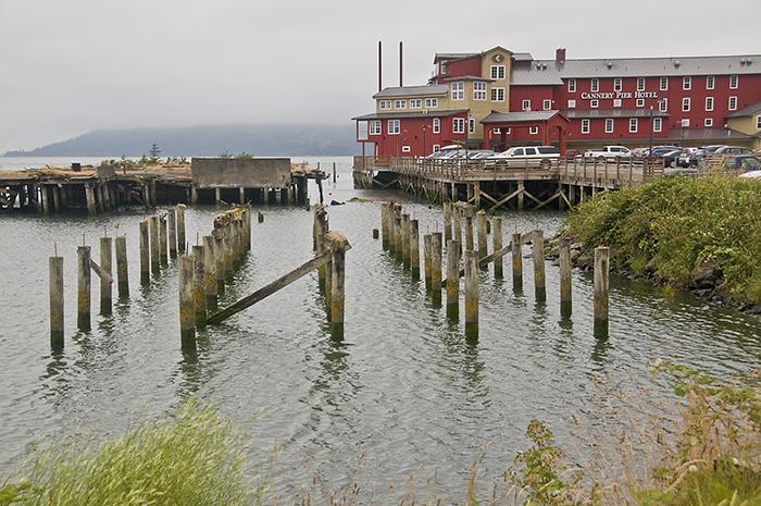
We hop back in our boats and paddle the waterfront. Astoria was built on piers—they literally supported local industry in a town wedged between the river and steep hills. They first supported salmon salteries, but fish still spoiled en route to London. Then Napoleon, struggling to supply his armies, offered a prize for a better way to preserve food, and canning was born—first in glass jars and then cans. Astoria boomed, and in 1883 had 39 canneries that shipped 43 million pounds of salmon.
Between fishing, canning, and shipping, Astoria developed as a rough-hewn blue-collar town with plenty of bars, some unsavory characters, and grim problems with alcohol, drugs, and prostitution. When logging and canning collapsed in the 1980s and fishing declined in the 90s, Astoria had to decide how to reinvent itself.
I spent a lot of time around Astoria and Warrenton in the mid 1990s, in the midst of the transition. Reluctant to give up it’s blue-collar heritage for tourism, the town’s unofficial motto, sported on bumper stickers and t-shirts, was “We Ain’t Quaint.”
Times have changed, partly. Burlington Northern’s abandoned waterfront railroad line now sports a waterfront trolley. It’s undeniably quaint. But it’s also hard to deny that things have improved. The trolley is crowded, as is a riverfront trail that provides access to the waterfront that had been inaccessible to the public. Where condos stand now, undeveloped brownfields had languished for years. Astoria now has a music festival, a farmer’s market, and an international film festival, a Fisher Poets Festival, and has been “discovered” by the New York Times and the New Yorker. The transition is well underway.
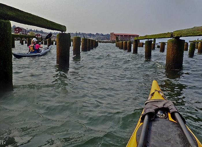
As we paddle along, Astoria’s identity straddles both worlds. One pier holds a decaying building. The next is a cannery that’s been converted into accountant and medical offices. Then there’s a set of condos and a brewery. After that, a maze of old pilings that provide housing for gulls. The pattern repeats. You could describe it as revitalization—or gentrification—half done. But I’m more hopeful. I think of it as coexistence between the history of the lower Columbia and a new way of embracing the river. New buildings next to empty pilings are fine with me, as is a brewery next to a fish smoking plant. The two aren’t mutually exclusive, and I think Astoria will figure it out.
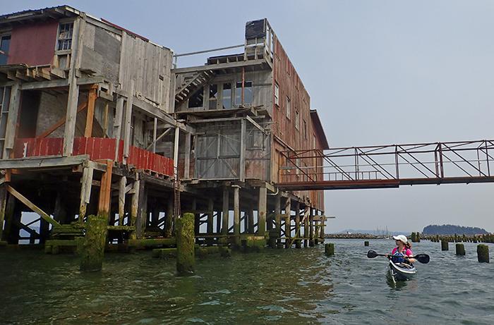
And Astoria’s waterfront is still a working environment. Soon we have to stop our conversation with the condo owner to make way for a Bar Pilot returning from the sea. Fishing boats come and go. Another tanker heads for the Pacific. Buoy Brewing’s bar has a glass floor looking down on the pilings and sea lions, a reminder of how the town was built. The sea lions bark, and the patrons wave.
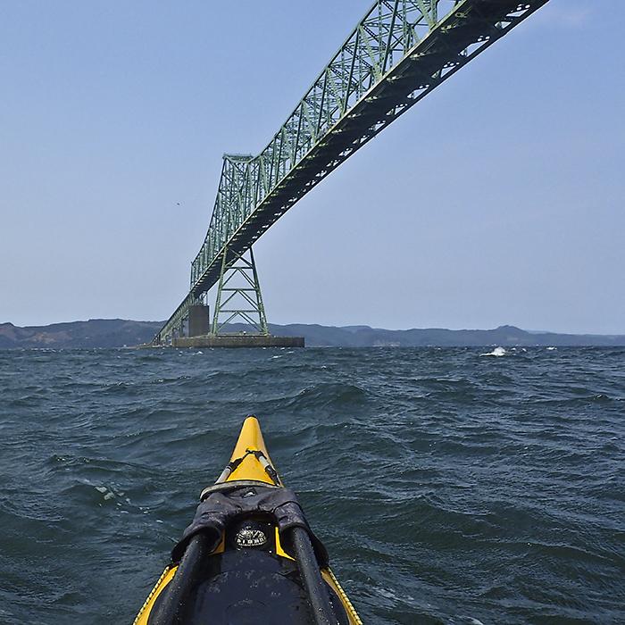
Then we’re under the bridge, a vast spanning arc that funnels the wind. Beyond that is the West Mooring Basin, our takeout, where another type of fishing rules: charters. We carry our kayaks past a cleaning table, where the day’s catch is being cleaned and filleted, big Chinook stacked on the table. The Basin’s waterfront buildings are, like Astoria, a mix: fishing supply stores, a hotel, a tax service, and the port of Astoria’s timber loading operation, all share a parking lot. We unload our kayaks amidst the fish cleaning.
Other Options:
Astoria offers other paddling options from our launch at the John Day River. Kayakers seeking more quiet waters can explore the marshy waters of Cathlamet Bay, paying close attention to the chart to avoid shallows at low tide. Another option is crossing to Rice Island, a mid-river dredge-spoil island with vast numbers of nesting gulls. Keep an eye on wind, current, and shipping during the crossing.
Why you should go: A mix of protected islands, the potentially dynamic water of Tongue Point, the Astoria waterfront, big ships, and sea lions.
If you go: Keep an eye on the mix of current and wind. Currents can be strong at Tongue Point, and westerly winds combined with an outgoing current can create chop. Stay out of the way of boat traffic large and small. Depending on currents, you can do this paddle in reverse or as a shorter out-and-back.
Distance: 7 miles from John Day Boat Ramp to the West Mooring Basin, or 4 to the East Mooring Basin.
Launch and Land: John Day River boat launch east of Tongue Point, taking out at the West Mooring Basin, or East Mooring Basin for a shorter trip focusing on Cathlamet Bay and Tongue Point.