Please note: Trip recommendations are reflective of site access and river conditions when they were developed. Changes to access sites, the shoreline, and river conditions regularly occur. Please double check access points before heading out. And if you see anything that needs correcting, please let us know!
Reach One: The Lower Gorge
-
Biddle's Beacon
Launch/Landing: Beacon Rock State Park, WA. River mile 141
Distance: 5 miles round trip (overnight option)
Skill Level: Intermediate to Advanced
Charts: NOAA 18531, Columbia River Vancouver to Bonneville
Tide Tables: Pacific Beaches with corrections for Beacon Rock State Park, WA.Directions: Beacon Rock State Park is located 35 miles east of Vancouver WA at milepost 35 on Highway 14.
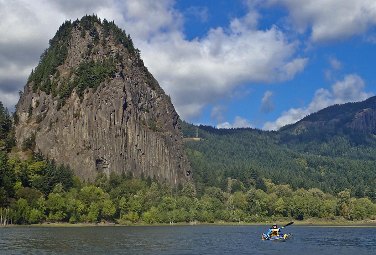
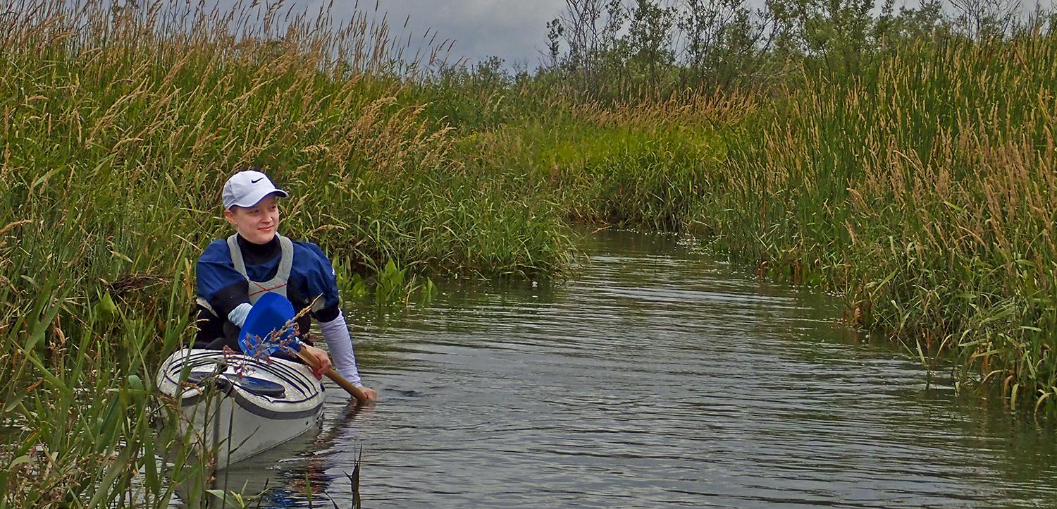
Description: Beacon Rock, named and described by Lewis and Clark as "a remarkable high rock," is a remnant of an ancient volcanic explosion; at 848 feet high it stands as a stunning landmark to guide a paddle around Pierce and Ives islands. Two hundred-acre Pierce Island is a Nature Conservancy preserve, and a haunt of osprey and beavers. Visitors are asked to stay only briefly and leave no trace. Heavily-wood Ives Island is part of the Gifford Pinchot National Forest. Adjacent to the islands are the wetlands and uplands of Pierce National Wildlife Refuge on the Washington shore (not open to the public) and on the Oregon side, John B. Yeon State Park, site of a trailhead to two of the Gorge's most beautiful and secluded waterfalls, Elowah and Upper McCord Creek falls. Surrounding views from the water encompass Hamilton Mountain, Aldrich Butte, Yeon Mountain, St. Peters Dome and Rock of Ages. Camping is available year-round at popular Beacon Rock. An easy trail leads to the summit of the rock, with panoramic views up and down the Columbia Gorge National Scenic Area from Wind Mountain to Crown Point. Henry Biddle purchased the rock to build a trail and in 1935 his heirs turned it over to the state for use as a park.
-
Rounding the Horn
Launch/Landing: Dalton Point, Oregon. River mile 133.6
Distance: 1-6 miles round trip
Skill Level: Intermediate to Advanced
Chart: NOAA 18531, Columbia River: Vancouver to Bonneville
Tide Tables: Pacific Beaches with correction for Ellesworth, WA (estimate only)
Directions: Dalton Point, at milepoint 29 of Interstate 84 in Oregon, is accessible only from the westbound lanes. If driving east, exit at Multnomah Falls then return two miles west to the Dalton Point boat ramp.
Description: At the western edge of the spectacular Columbia River Gorge, Dalton Point is gateway to geologic beauties and fine sandy beaches. Just over a mile downriver, near the Washington side, rises a rugged basalt pillar, remnant of massive landslides eons ago. Lewis and Clark named it Phoca Rock for the many harbor seals, Phoca vitulina, they saw nearby. The main shipping channel runs between the Rock and shore; large commercial craft, especially tugs and barges, can approach quickly and almost silently. This area can also be hazardous with winds and rough water. Cape Horn, with its impressive towering basalt cliffs rising directly out of the river, waterfalls and small caves, lines the shore beyond. Mid-river is Sand Island, a partly-forested, undeveloped part of Rooster Rock State Park. Its extensive sandy beaches are clothing-optional. Lewis and Clark camped from April 6 to April 8, 1806 just downriver from the island. Shuttle trips can be continued downriver, to land at Rooster Rock State Park (RM 128.5, five miles from Dalton Point) or Corbett Ramp (RM 126.5, seven miles from the launch). -
Steamboat Legacy
Launch/Landing: Steamboat Landing Park, WA. River mile 123
Distance: 6 miles round trip
Skill Level: Intermediate to Advanced
Charts: NOAA 18531, Columbia River: Vancouver to Bonneville
Tide Tables: Pacific Beaches with corrections for Washougal, WA.Directions: The park is located in Washougal, WA, at Highway 14 and 15th Street.
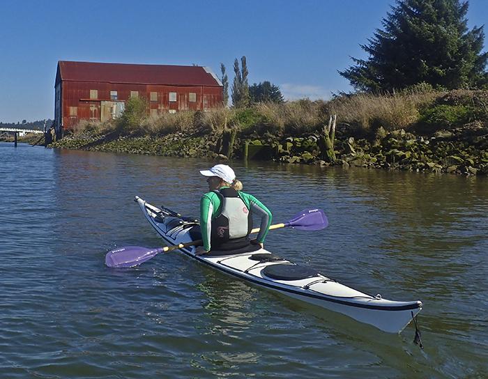
Description: A Clark County Heritage Site, Steamboat Landing offers both a beach launch and a floating dock. In the 1880s, it was the home port for the steamer Calliope, and some of the pilings are still visible a few hundred yards upstream from the site. Remnant dock pilings and pieces of pipeline at the landing are the remains of a Pendleton Woolen Mills dock for unloading oil, used from the 1920s to the '40s. A mile upriver is the Captain William Clark Park at Cottonwood Beach, and a mile downriver is the Port of Camas-Washougal Boat Ramp. Lady Island is three miles downriver. In 1805 Lewis and Clark estimated its size at 3 1/2 miles long and 1 1/2 miles wide. They watched more than a thousand waterfowl pass over its head and named it "Island of Fowls." Today Highway 14 crosses over the island, which is now the property of Crown-Zellerbach Corporation; part of it is a pulp mill but the island's sandy beaches revealed at low water are fine for a picnic lunch. At the upriver end of the island are the mouths of two rivers—in Washington the Washougal River and in Oregon the delta of the Sandy River—both excellent waterways for further exploration.
Reach Two: Urban Nature
-
Paddling the Ports, Wildlife Bonus
Launch/Landing: McCuddy Marine Docks, Oregon. River mile 107
Distance: 12 miles round trip
Skill Level: Beginner to Intermediate
Charts: NOAA 18531, Columbia River: Vancouver to Bonneville, and
NOAA 18525, Columbia River: St. Helens to Vancouver.
Tide Tables: Pacific Beaches with correction for Vancouver, WADirections: Interstate 5 north to Jantzen Beach exit, drive a half mile along NE Tomahawk Island Drive to the Alder Creek Kayak and Canoe store parking lot.
Description: Huge international cargo ships at anchor, dry docks, cranes, pilings, piers, grain silos, and stevedores at work provide a fascinating backdrop for exploring the busy inland seaports of Portland, Oregon and Vancouver, Washington. A circumnavigation of Hayden and Tomahawk Islands (now one connected narrow island, about 5.5 miles long) offers a flavor of urban river ambiance—the Port of Portland's Terminal 6, marinas and floating houseboat communities, overhead the Interstate Bridge and low-flying airplanes from the Portland International Airport. Lewis and Clark called Hayden "Image Canoe Island" after the highly-decorated canoes they saw in the area; from here they spotted and named Mount Jefferson. More than 800 acres of the island's northern half are undeveloped and sit at the intersection of two major wildlife corridors. The cottonwood-ash forest is one of the largest intact stands left on the lower Columbia and the area is used by more than a hundred wildlife species, including bald eagles, pileated woodpeckers and painted turtles.
-
Park to Park
Launch: Vancouver Landing Public Dock, WA. River mile 106
Landing: Frenchman's Bar Park, WA. River mile 100
Distance: 6 miles; requires shuttle
Skill Level: Intermediate to Advanced
Charts: NOAA 18531, Columbia River: Vancouver to Bonneville
Tide Tables: Pacific Beaches with correction for Vancouver, WADirections: The launch is an amphitheater on the Vancouver Waterfront, just west of the I-5 bridge and near 100 Columbia St. From the City Center exit (Sixth St.) off Interstate 5, proceed three blocks to Columbia St., turn left and then right into the landing's parking lot.
Description: A city park, major hotel and restaurant lining the shore set the stage for a decidedly urban paddle. Downriver, gargantuan grain silos and huge international cargo ships at dock or anchored mid-river dwarf a small craft, while a view upriver reveals marinas, moorages and multi-story condos. Vancouver, population 175,000, is the seat of Clark County, its rapid growth reflected in an expanding city skyline and construction cranes. Four mile-long Hayden Island, its northern half undeveloped, makes a transition to a more natural shoreline. Just past Hayden's downriver end is the Willamette River's confluence with the Columbia at Kelley Point Park in Oregon. From here, Sauvie Island comprises the Oregon shore and commercial shipping traffic from both rivers merges into a busy river highway. A mile past the point, Frenchman's Bar (named for Paul Haury, a French sailor who jumped ship) has more than a mile of sandy beaches and a 2 1/2 mile trail that connects the 120-acre regional park with Vancouver Lake Park. Other paddle options launching from Vancouver include Vancouver Marine Park (WA RM 108) to Kelley Point Park (OR RM 101).

Reach Three: Sauvie Island & Scappoose Bay
-
Around the Island: two days and 43 miles around Sauvie
Reach: 2-3
Launch and Land: Frenchman’s Bar, Scappoose Bay, Sauvie Island Boat Ramp on Multnomah Channel, Cathedral Park or Kelly Point Park on the Willamette
Distance: 43 miles to circumnavigate from Frenchman's Bar, many shorter trips are possible.
Chart: NOAA Chart 18525, Columbia River, St Helens to Vancouver
Skill level: Intermediate or beginner, depending on distance -
Camp on Coon Island
Launch: Sauvie Island Boat Ramp, OR. River mile 101, Multnomah Channel RM 18
Landing: Gilbert River Boat Ramp on Sauvie Island. River mile 91, Multnomah Channel RM 7.5
Distance: 10 miles overnight (or 15 miles round trip)
Skill Level: Beginner
Chart: NOAA 18524, Columbia River: St. Helens to Vancouver
Tide Tables: Pacific Beaches with correction for Multnomah Channel - Fort William Bend, ORDirections: Launch: Sauvie Island is approximately 10 miles northwest of Portland. Follow Highway 30 to the Sauvie Island bridge; the road becomes NW Sauvie Island Rd. Follow it for approximately 2.5 miles, turn right onto NW Ferry Rd. leading to the boat ramp.
Directions: Landing: Follow Highway 30 to the Sauvie Island Bridge, then turn left at the bottom of the ramp to Gillihan Rd. At approximately 6 miles it turns into Reeder Rd; follow for approximately 7 miles, then turn left at the boat ramp sign into the parking lot.Description: Part of the Willamette River Greenway, Multnomah Channel is a narrow, 21-mile stretch connecting the river with the Columbia. Before a bridge was built in 1951, the launch site was a ferry landing for islanders traveling to and from the mainland. Along the first two miles downriver, shores are lined with ash, willow, and cottonwood forests—Wapato Access Greenway State Park on the right, and on the left, mainly Metro Parks and natural areas, where more than 20,000 trees have been planted to stabilize the banks and provide shade cover for fish habitat. The northern 12,000 acres of Sauvie Island are owned by Oregon Department of Fish and Wildlife and managed for waterfowl habitat. Great blue heron, belted kingfishers and bald eagles are regularly seen; during migrations, sandhill cranes and tundra swans commonly fly overhead. As the channel nears the outskirts of Scappoose, marinas and floating homes solidly line the left shoreline, with agricultural fields beyond. A floating restaurant, Mark's on the Channel, is a popular stop. At River Mile 93 (or Multnomah Channel RM 8) the J.J. Collins Marine Park (also known as Coon Island) offers camping on the west and east sides. Approximately 1 1/2 miles downriver, just after the mouths of Cunningham Slough and the Gilbert River, the Gilbert's boat ramp is easy to spot.
-
Little Slough to Big River and Back
Launch/Landing: Ridgefield Kayak Launch, WA. River mile 90
Distance: 10 miles round trip
Skill Level: Beginner to Intermediate
Chart: NOAA 18525, Columbia River: St. Helens to Vancouver
Tide Tables: Pacific Beaches with corrections for St. Helens, ORDirections: Interstate 5, take Exit 14 (Ridgefield) and head west on Highway 501 for about 3 miles into town. Turn right at Main Avenue, then 3 blocks to Division Street to the kayak launch.
Description: From the launch site on Lake River, this scenic circumnavigation of Bachelor Island begins on narrow, tree-lined waterways. First heading north for about a mile, then sharply turning south into Bachelor Island Slough, the route wends along the main unit of Ridgefield National Wildlife Refuge. Great blue heron, belted kingfisher and a host of other migratory and resident birds are likely to be seen along this stretch of the refuge, managed to protect habitat for waterfowl and other wetland wildlife. After two miles, the small slough meets the expansive, open-water Columbia. With Sauvie Island in the distance on the opposite shore, Bachelor's sandy beaches offer a glorious spot for lunch or lazing about. Changeable weather and strong winds can result in dangerous conditions heading downriver. At the confluence with Lake River, a short paddle returns to the launch. The trip can be lengthened by crossing the Columbia to the north shore of Sauvie Island and a stop at Warrior Rock Lighthouse.
-
Gunkholing in Scappoose Bay
Launch/Landing: Scappoose Bay Marine Park, OR. River Mile 89 (or a mile up Scappoose Bay from Multnomah Channel RM 2)
Distance: 2-5 miles round trip
Skill Level: Beginner
Charts: NOAA 18524, Columbia River: Crims Island to St. Helens
Tide Tables: Pacific Beaches with correction for Scappoose Bay, ORDirections: Follow Highway 30 to the town of Warren, turn east on Bennett Rd. at milepost 25.8, then an immediate left on Old Portland Rd, then another half mile to the marina.
Description: Scappoose Bay is a gunkholer's paradise, an intricate web of wetlands and mostly unnamed creeks, tributaries and channels that meander and curve and switchback and slice through islands and veer into lakes and flow into each other—or simply peter out, so tide tables should be carefully checked. The bay's watershed drains about 85,000 acres and has been identified as a major salmon and steelhead spawning and rearing area. Paddling in the bay is a sheltered float in protected waters amid the sights and sounds of myriad birds, including bald eagles, cormorants, and woodpeckers. Depending on the course, sights might include old farmhouses, pastures with grazing cows, logging pilings from yesteryear, expanses of arrow-leafed native wapato plants, or canopies of overhanging trees. The marina includes Next Adventure's Scappoose Bay Paddling Center, purveyors of kayaks and gear, food, rentals and guided tours.
-
Island's End
Reach: 3
Launch and Land: Scappoose Bay, Ridgefield, St. Helens, or the mouth of the Lewis River.
Distance: 10 miles Around Bachelor Island from Ridgefield
7 miles round-trip to Warrior Rock from Scappoose Bay
Chart: NOAA Chart 18525, Columbia River, St Helens to Vancouver
Skill level: Beginner
Reach Four
-
To Historic St. Helens
Launch/Landing: Pixie Park, OR. River mile 84
Distance: 4-5 miles round trip (overnight option)
Skill Level: Intermediate
Chart: NOAA 18524, Columbia River: Crims Island to St. Helens
Tide Tables: Pacific Beaches with corrections for St. Helens, ORDirections: Highway 30 to Columbia City. Turn east on First Street and follow it for four blocks to Pixie Park.
Description: Pixie Park's small gravel beach provides a gentle launch into the Columbia. Because this jaunt begins by paddling upriver, checking tide tables is a must. The city of St. Helens is only two miles upriver, but depending on wind and weather, the short distance can be a challenge. Out of the main shipping channel, this stretch poses an opportunity for watching the passage of international cargo ships from a safe vantage point. The town was likely named for the view of 8,364-foot Mount St. Helens, a volcano formerly 9,677 feet; steam plumes occasionally still rise from its crater. Boat tie-up is available at the city-owned public docks. A ramp leads up to the National Historic District, for a tasty brunch or a stroll past architectural treasures. Sand Island Marine Park, a short distance offshore, offers the opportunity for a detour or overnight stop. The park features nature trails and sandy beaches, and the upriver end of the island has an expansive view of rivers, channels, islands and the broad Columbia upriver.
-
Beyond Coffin Rock
Launch/Landing: Goble Landing, OR. River mile 74
Distance: 11 miles round trip
Skill Level: Intermediate to Advanced
Charts: NOAA 18524 Columbia River: Crims Island to St. Helens
Tide Tables: Pacific Beaches with correction for Goble, ORDirections: Drive nine miles past Columbia City to Scipio's Goble Landing boat ramp, 70360 Columbia River Highway (Highway 30).
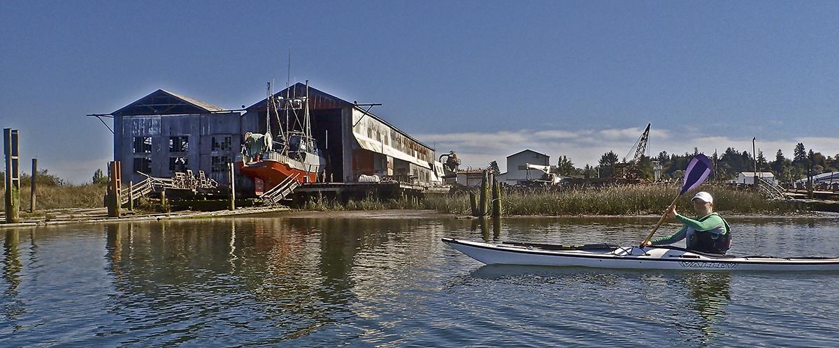
Description: Dock houses line the floating walkway next to the boat ramp in the small town of Goble where from 1884 to 1908 the Tacoma, then the second largest ferry in the world, transported trains across the Columbia. One mile downriver is Coffin Rock, once an Indian burial place. A mile further is a geologic feature known as the Klatskanic Divide, where the topography dramatically changes. The western portion rises steeply to 1,500 feet while the eastern portion is a flat alluvial plane. Just beyond is the mile-long sandy Prescott Beach, a Lewis and Clark campsite and today a favorite spot for windsurfing. Prescott faces the upriver end of Cottonwood Island across the river in Washington. This paddle continues along the Oregon shore for the island's 3 1/2 mile length. A careful crossing to the Washington side at the island's downriver point leads to the mouth of the Cowlitz River, a course upriver on Carroll's Channel behind the island, and a crossing back to Goble. A round trip between Goble and Prescott Beach is six miles. Another option is to launch at Prescott to circumnavigate Cottonwood Island.
Reach Five: The Gorge
-
Dabbling Around Dibblee Island
Launch/Landing: Dibblee Point Beach Landing, Oregon. River mile 64
Distance: 1-5 miles round trip (overnight option)
Skill Level: Beginner
Chart: NOAA 18524, Columbia River: Crims Island to St. Helens
Tide Tables: Pacific Beaches with correction for Dibblee Point, ORDirections: A mile north of Rainier on Highway 30, turn right onto Rockcrest Street, then left of W. Rainier Dike Road. Follow the road as it turns into a network of primitive roads leading to a beach.
Description: Within view of the Lewis & Clark Bridge, Dibblee Island marks the transition between the industrial zones of Longview and Rainier and the more primitive islands and wild landscapes downriver. In the distance are steep-shouldered bluffs and 500-foot Mount Solo on the Washington side. Because the islands are close to the Oregon shore, they are out of the main shipping channel, offering more protected paddling. The two islands (actually they're one island officially known as Lord Island) are divided by a slough, with plenty of inlets for backwater exploring. Cottonwoods and other trees, along with a vine maple understory, make for classic Columbia River islands, with the maples a brilliant red in autumn. Just downriver from Lord is Walker Island, where Lewis & Clark camped March 26, 1806. Clark wrote, "I saw some deer & Elk at a distance in the Prarie. we continued untill late in the evening and encamped on a Small Island near the Middle of the river haveing made 18 miles." For an overnight trip, primitive camping is permitted on the east, north, and south sides of Lord Island (RM 62.5 and 63).
-
Island Drift
Launch/Landing: Abernathy Creek Boat Ramp, WA. River mile 54
Distance: 8 miles round trip (overnight option)
Skill Level: Intermediate to Advanced
Charts: NOAA 18523, Columbia River: Harrington Point to Crims Island and 18524, Columbia River: Crims Island to St. Helens
Tide Tables: Pacific Beaches with correction for Abernathy Point, WADirections: From milepost 48 on Highway 4 (about 14 miles west of Kelso), turn north onto Abernathy Creek Road, then turn left and follow a dirt road to the launch. At low tide, launch the small beach at the mouth of the creek.
Description: Many islands of the lower Columbia appear to be surrounded by small isles that were once part of a whole. Three-mile-long Crims Island is such a site, with Gull Island and four small unnamed islands around it, and another two nearby in Bradbury Slough, making it an island "complex" with byways for exploration. Lewis & Clark called it "Fanny's Bottom," presumably after Clark's sister Frances. Beginning at Abernathy Creek Boat Ramp in Washington, this paddle route crosses the shipping channel for a circumnavigation around Crims, then a jaunt downstream past Oak Point to Quill Island before a return to the Abernathy ramp. In the late 1800's, Astoria was known as the "salmon canning capital of the world" and the area around Oak Point contributed to that catch, with about fifty horse-drawn seine net crews and hundreds of wooden fishing traps at work. Primitive camping is available on Quill Island.
-
The Lower Gorge: Secret Spots, Back Channels, Changeable Plans
Launch/Landing: County Line Park west of Longview, and Skamokawa Vista Park
Reach: 5 & 6
Distance: 10-16 miles, depending on route specifics
Chart: NOAA Chart 18523, Harrington Point to Crims Island
Skill level: Intermediate
Tide Tables: Columbia River - Cathlamet Channel
Reach Six: Refuges
-
The Lower North Shore: Skamokawa to Brookfield Point
Launch and Land: Vista Park in Skamokawa
Distance: 12 miles round-trip
Chart: NOAA Chart 18523, Crims Island to Harrington Point
Skill level: Intermediate
Tide Tables: Skamokawa, WA -
Sheltering Slough
Launch/Landing: Skamokawa Boat Ramp, WA. River mile 32
Distance: 1-5 mile round trip, or overnight
Skill Level: Beginner
Chart: NOAA 18523, Columbia River: Harrington Point to Crims Island
Tide Tables: Pacific Beaches with correction for Skamokawa, WA.Directions: From Interstate 5 north, Longview/Kelso exit, take Highway 4 west to Skamokawa. For the public boat ramp, turn left across Skamokawa Creek Bridge then south down Pleasant Point Road. Other launch options include the Skamokawa Paddle Center dock, and Vista Park beach.
Description: A web of waterways stream around the vicinity of the historic town of Skamokawa—Elochoman Slough, Steamboat Slough, Brooks Slough, Skamokawa Creek, and Red Slough on Tenasillahe Island mid-river. Picturesque Brooks Slough, with its forested shores and mountain backdrop, is a protected waterway that can be traveled about two miles upstream to its mouth in the Julia Butler Hansen Refuge for the Columbian White-tailed Deer. Skamowaka was known at the turn of the century as "Little Venice." Scattered along the north shoreline are small homes, docks, boats, buildings on stilts, and old pilings that give a flavor of the slough's past as a bustling river community. Black- and white-tailed deer and Roosevelt elk are observed year-round, and beavers and muskrats can often be seen. During low tides, sandbars and exposed logs can hinder travel. For overnight stays, camping is available at Skamokawa Vista Park, and lodging exists at the historic Skamokawa Inn.
-
Into the Wilderness
Launch/Landing: Knappa Docks, OR. River mile 28
Distance: 1-10 miles round trip
Skill Level: Beginner to Advanced
Charts: NOAA 18523, Columbia River: Harrington Point to Crims Island
Tide Tables: Pacific Beaches with correction for Knappa SloughDirections: At milepost 82 on Highway 30, turn north and follow Knappa Dock Road for 1.5 miles.
Description: Knappa is the launching point for two very different paddling experiences, yet each with a feel of wilderness. The first, and more sheltered, is Blind Slough, about a mile upriver. The slough is a preserve of the Nature Conservancy, and the best remaining example in Oregon of a Sitka spruce swamp (some of the trees are 400 years old), once common in coastal estuaries from here to Alaska. Along the channels are wildflowers and dense thickets of willow, twinberry, and nootka rose. Just across Knappa Slough from the launch is Karlson Island and the chain of dozens of estuary islands, bars, mud flats and tidal marshes that are part of the 35,000-acre Lewis and Clark National Wildlife Refuge. During peak northern migration in February and March, the Refuge provides habitat for as many as 1,000 tundra swans, 5,000 Canada geese, and 50,000 ducks. Access to these areas is also available by launching at Aldrich Point (OR RM 30), John Day Boat Ramp (OR RM 18), or one of the three Skamokawa launches (WA RM 32).
-
Two Rivers and Grays Bay
Launch/Landing: Oneida Boat Ramp, WA. River mile 22
Distance: 1-6 miles round trip (overnight option)
Skill Level: Intermediate to Advanced
Charts: NOAA 18523, Columbia River: Harrington Point to Crims Island
Tide Tables: Pacific Beaches with correction for Grays River Entrance, WADirections: From mile 10.8 on Highway 14, turn south onto Oneida Road and follow it for two miles to the boat ramp.
Description: With Grays Bay to the north and Cathlamet Bay to the south, the Columbia is at its widest here, with grand, expansive views of the river and distant hills and bluffs. Rice Island, approximately 2 1/2 miles from the launch, is a dredge spoil island with acres of river sand. Vegetation is being established to deter Caspian terns, whose colony was relocated because of their feeding frenzies on the estimated 100 million young salmon who linger in spring in this zone of mixing salt- and freshwater. Deep River, Grays River and its tributary Seal Slough all empty into the bay and offer tranquil, wildlife-rich paddling past valley meadows and forested shoreline, with homes, docks, and fishing shacks along the lower reaches. In two mile-long Seal Slough, snags of red cedar trees buried in an earthquake in January 1700 are exposed. Camping is available at a private campground in Oneida. Grays Bay is named for American Captain Robert Gray, who explored the mouth of the river in 1792 and named it for his ship, the Columbia Rediviva.
-
Island Maze: Aldrich Point to Pillar Rock
Launch and Land: Aldrich Point or Knappa. Blind Slough is most quickly accessed by the informally-named Autio Boat Launch, privately owned but open to public use.
Distance: 14 miles from Aldrich Point to Pillar Rock and back
Chart: NOAA Chart 18523, Columbia River, Harrington Point to Crims Island
Skill level: Beginner to Intermediate, but navigation is challenging
Tide Tables: Columbia River - Aldrich Point
Reach Seven: The Estuary
-
On the Waterfront: Astoria by Kayak
Launch and Landing: John Day River boat launch east of Tongue Point, taking out at the West Mooring Basin
Distance: 7 miles from John Day River to West Mooring Basin
Chart: NOAA Chart 18521, Columbia River, Pacific Ocean to Harrington Point
Skill level: Intermediate
Tide Tables: Astoria (Tongue Point) -
Lewis and Clark's Landing
Launch/Landing: Netul Landing, Oregon. River mile 13, Lewis & Clark River
Distance: 1-6 miles round trip
Skill Level: Beginner
Chart: NOAA 18521, Columbia River: Pacific Ocean to Harrington Point
Tide Tables: Pacific Beaches with correction for Lewis and Clark River Bridge, OR
Directions: From Astoria, take Alternate Highway 101 south, turn left onto Fort Clatsop Road; Netul Landing is approximately 1.5 miles beyond the Fort Clatsop site.Description: Netul Landing is the heritage spot where The Corps of Discovery landed on December 7, 1805 to establish a winter encampment. Clark wrote, "this is certainly the most eligable Situation for our purposes." Now a part of the Lewis and Clark National Historical Park, the landing features information kiosks, a bronze statue of Sacagawea, and a canoe/kayak boat launch into the Lewis and Clark River. A small waterway, with Saddle Mountain in the distance, it meanders north past woods and pastoral fields. Pilings—remnants of logging operations—jut from the water near shore. After about two miles downstream, the river widens considerably into the open waters of Young's Bay. Astoria and Smith Point are visible from the river's mouth. At low tide, Young's Bay becomes mudflats; tide tables should be consulted for optimum passage with tides and river current, since the return trip will head upriver. From the landing, a half-mile walking trail leads to Fort Clatsop.
-
Of Turns and Terns
Launch/Landing: Port of Ilwaco, WA. River mile 3
Distance: 6 miles round trip (overnight option)
Skill Level: Experienced
Charts: NOAA 18521, Columbia River: Pacific Ocean to Harrington Point
Tide Tables: Pacific Beaches with correction for Baker Bay, WADirections: From Highway 101 in Ilwaco, turn on Elizabeth Street and continue to the ramp at the mooring basin.
Description: Ilwaco is a small traditional fishing port with an 800-boat marina, sheltered in Baker Bay on the Long Beach Peninsula. It's the gateway to Cape Disappointment State Park (formerly Fort Canby State Park) and its Lewis & Clark Interpretive Center. In this bay, which they called "Haley's," Clark wrote that they were "in full view of the Ocian" and finally had achieved their goal of reaching the Pacific. In the center of the bay, from one to three miles from the launch, are two islands, West Sand and East Sand. West Sand, with its native dunegrass, has been proposed for designation as a national natural landmark. East Sand is the nesting site of nearly 10,000 breeding pairs of Caspian terns—the largest colony in the world. It was also formerly the site of the largest colony of double-crested cormorants in the Pacific Northwest—up to 28,000—before hazing operations dispersed the birds to other locations along the river, such as the Astoria-Megler Bridge. Up to 10,000 brown pelicans have occupied the island, along with species of loons, grebes, gulls, and abundant shorebirds and waterfowl during spring and fall migrations. Visitors are not permitted on East Sand, but primitive camping is available on West Sand Island.
-
Youngs Bay: Paddling with Merriweather and Lewis
Launch and Landing: Netul landing, ¼ mile south of Fort Clatsop. Other launch options are Youngs Bay Marine Park for exploring the Youngs River, the Warrenton Marina for access to the Skipanon, and the Hammond Boat Basin
Distance: 2 miles to Youngs Bay from Netul Landing, another 2 to Smith Point
Chart: NOAA Chart 18521, Columbia River, Pacific Ocean to Harrington Point
Skill level: Beginner
Tide Tables: Astoria (Youngs Bay)
